Thursday, Day 4 – Our Rapid Descent
We were all tired from lack of sleep and the low oxygen level.
Fred was hurting head to toe, inside and outside.
Steve’s headaches were becoming more severe.
I was angry at the incessant wind and frustrated that it had kept us awake and slowed our progress.
AMS was taking its toll on all of us.
Only Christina, at the lead position, seemed to be in relatively good shape.
We had pushed our safety factor to the limit.
Steve looked to the summit and the west to see some ominous clouds cresting the mountain and coming our way.
Fortunately, among the four of us we were able to find enough common sense to start our rapid descend.
We radioed to Grace and Katie and told them our plan; you could almost sense the relief in their voices.
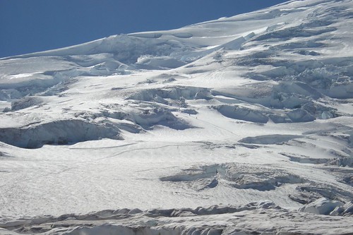
The sun was up and with our backs to the wind our visibility improved. Several hundred feet below we could see our gear lashed to the mountainside at our high camp, our next goal. We reminded ourselves that most accidents happen on the way down when climbers are most vulnerable due to fatigue and a sense of accomplishment. Going down uses a whole different set of muscles and different techniques with poles and ice axes. Not any more difficult, just different, plus you have gravity in your favor. Steve reminded us that the lower we got the better we would feel; Christina kept singing the praises of O2. Fred forgot to take pictures at our summit, later he told us he was too busy trying to stay alive. Going down gives you an entirely different view. On the way up you face the mountain, looking down for each successive step, looking up to see the snow or rock that you need to climb. On the way down you get to see the beauty of the surrounding mountains and valleys and rivers and sky. You also get the full realization of what you have accomplished; where you started, the route you took, the glaciers you crossed; it’s a great feeling that helps to mask the pain you are experiencing. We started down.
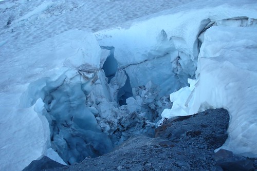
Mother nature wasn’t finished with us. We had descended a short distance when we were hit by what felt like ice pellets. We dug our ice axes into the snow and held on. It was like this most of the way down to high camp. After a brief rest at high camp we loaded up our packs and continued down towards base camp. We maintained radio contact with Grace and Katie who were watching us descend. They in turn sent messages to Matt so he could keep Kathy and Arlene appraised. They were also readying everything at base camp so we could continue on down. We were making good progress. In the process of crossing a crevasse, about 4 feet wide followed by a steep slope, Steve yelled SNOW SLIDE – RUN. Christina and I were across the crevasse, Fred probably in mid-air and Steve still dug-in to protect Fred from a fall; and we heard SNOW SLIDE – RUN. Christina and I ran and slid down the mountain dragging Fred behind us and in a single leap Steve bounded over the crevasse and slid down with us. We looked back and saw a cloud of snow as the avalanche went by and fell into another crevasse. It was really cool. Sliding was fun too, so we continued to slide down perhaps another hundred yards.
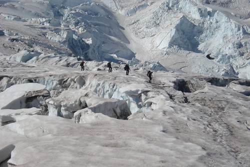
The avalanche fell into a crevasse above us at this spot on the mountain... you can see two little dots of us in the center of the frame. Follow the zig-zag foot path up the snowfield, we are at the point on the path where the glacier breaks. This is near the same location where I fell into the crevasse the day before...
With Christina still in the lead, we approached our final set of crevasses above base camp, negotiated them without incident and in a few hundred yards were on solid ground at Camp Schurman. We had come down 2500 ft, the air was better, the water refreshing and yet the thoughts of food were still …, let me just say we weren’t ready for any. I do recall sitting at base camp eating a packet of peanut butter and trying to figure out what I needed to do next. I also recall thinking we were less than half way down to Glacier Basin Camp.
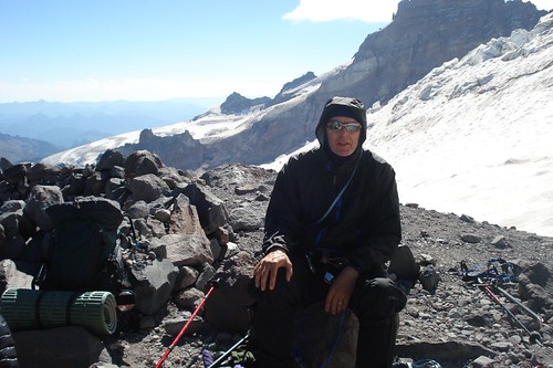
Fred resting up for the next descent...
While we were having fun on the slopes, Grace and Katie were becoming good friends with Abby. They also restocked the water supply and sorted all the gear and gave all our excess food and fuel to Abby, now that significantly lightened our load. Abby even took a lot of our trash; better to take it down by helicopter she said, rather than for us to carry it – thanks Abby.
We rested for perhaps an hour, loaded up, roped up, said our good-byes to Abby and Camp Schurman and headed out. The scary snow-bridge was now a pile of rubble at the base of a 50 ft deep crevasse. We took the long way around and started down Emmons Glacier, Christina in the lead. We wound our way through the crevasse field that had changed a bit in the few days since our ascent. One crevasse in particular stands out in our minds; about a four foot jump onto a four foot landing spot of ice, don’t go any farther or you fall down the next crevasse.
We were so focussed during this part of our descent that no one managed to take a photo of the terrain. It's hard to forget though, and here's a sketch of the rotting ice of the mid-Emmonds glacier...

Over time, this event will require a Herculean leap to stick a 10 point landing on a postage stamp; well maybe I exaggerate. We all made it and were starting to feel really good about our mountaineering skills. We stepped off Emmons Glacier, paid proper tribute to the “special sisters spot” and started up the loose dirt and rock ridge. At the top of the ridge we stopped for a brief rest and to enjoy the view; we were aware that as we descended we would lose this spectacular view. There are no trees at this elevation and very little if any vegetations at all. The rocks are interesting in that there is such a variety; Christina found a good one for Kathy. The air seemed thicker and I guess we were probably starting to feel a little better. Well maybe that’s a stretch.
We descended the ridge onto Inter Glacier and met another team heading up. It was Thursday and the weekend climbers were arriving. Fun time again and we took the opportunity to slide down maybe a few hundred feet before we started to encounter ice. Snow is ok, but ice can be a real pain even with crampons. A few days earlier it was all snow. There were some crevasses but they were narrow and not a problem. What was quite interesting was that we were walking on the ice that forms the White River that we could see below. At one crevasse I stopped to listen to the water flowing beneath the glacier. It was a narrow one, very deep, the thickness of the glacier, deep blue as it went down and the sound of running water. Very cool. The concerns we had as we descended were slipping on the ice and the constant hazard of rock falls. Once a rock loosens from the glacier it becomes an unguided missile bouncing erratically down the mountain; sometimes picking up friends in it travels. Can be very dangerous.
The InterGlacier from below after our descent. The gray areas in the center are ice where just two days earlier it was snow.
.jpg)
We were all hurting, our equipment needed adjusting, tighten boots, tighten crampons, remove outer layers; but icy slopes are a bad place to stop. We actually lost our way on a wide open glacier and changed directions a couple times. The sun was starting to get blocked by clouds and would soon be hidden by a ridge on our left. Just over the next crest was the last snow field on the glacier. We started to slide down but Katie got her leg caught in a rope and twisted her knee. Katie did not have a good experience on Inter Glacier; either going up or down. Fred’s feet were really hurting so he and Steve continued to slide down the last few hundred yards to the bottom while Katie, Grace, Christina and I walked down. At last solid ground once again, no more snow or ice, relatively solid path and only 2 miles to camp.
The team sort of strung out during this last hike to camp. Steve and Grace seemed to have more energy than the rest of us and soon were way ahead. Katie and Fred about 100 yards behind them and Christina and I dawdling at the back. Oh, I forget to tell you earlier that this was the area where we had seen several wild sheep on our way up. I don’t know what they were surviving on as there is no vegetation where they were headed. Keep in mind that this area is covered with snow and ice most of the year so flowers don’t have much of a chance to flourish. Off to the sides where the glaciers didn’t encroach, there was a variety of plant life and small patches of grass and some really big granite boulders that look out of place. The lower we got the more vegetation we encountered until we were surrounded by trees at the camp site.
As I mentioned, Steve was way ahead of us, got to camp then returned to meet us on the trail to carry my pack to camp then returned again to carry Fred’s. By the time Fred and I reached camp Steve & Grace had already set up our tent; which was a good thing because we might not have had the energy to even bother. Katie retrieved her very comfortable sneakers that she had cached in a tree; Christina filled the water bottles and Grace boiled them. Food was essential but Fred and I were still treating it as optional. Christina had been giving all of us some magic elixir each night that was supposed to cure what ails you, it tasted terrible and I confess to not drinking my daily prescription. Fred on the other hand did and it probably helped him as he and food were still very much strangers. I was able to force down a half portion of ravioli that night along with a generous serving of water, a snack bar and some elixir. Messages were sent to Matt and Kathy that we hoped to arrive at the parking lot at about 11:00 AM the next day and it sure would be nice if they could bring a few items like real food, milk, beer ….
This very long day was nearly over for our team. We had started at about 2:00 AM after an almost sleepless night, attempted to summit, got pretty well beat up by the wind and descended 6000 ft to Glacier Basin Camp arriving at about 5:30 PM; exhausted.
While all this was going on there was the other team that did summit. I wrote about that team in “By the Numbers” but it bears repeating here. That team consisted of 3 climbers: 2 climbers who were making their 71st ascent in 30 years (and refused to miss a year) and accompanied by Dale, an Army friend of Steve’s – Special Forces, attached to the Army Northern Warfare School stationed in Alaska, extensively trained in mountaineering. They met with us at about 3:00 AM at our high camp on their ascent. Their ascent and return to base camp took 14 hours, normally 8 hrs to 10 hrs. Our team at 12000 ft was the second highest team that day.
Dale had been in radio contact with Steve throughout the day. Unfortunately during their climb Dale had suffered snow blindness and was having difficulty making it down. He was hoping to meet with us at Glacier Basin Camp. At 6:00 PM Steve ascended once again to about 8500 ft to find Dale who by this time was "mis-oriented" on the rocky ridge separating Emmons and Inter Glaciers. They were in radio contact but could not connect. They decided Dale would camp where he was and Steve returned to Glacier Basin, arriving at about midnight. Friday at about 6:00 AM Steve headed back up the mountain, found Dale and they returned to Glacier Basin Camp. Steve’s ability and dedication to his fellow officer enabled him to push himself well beyond what any of us might expect.
That was our day; one of the most physically and mentally taxing and memorable we have had.
Here's a link to the route we took on Day 4 on mapmyrun.com. At the bottom of the map click "Topo" or "Satellite" for a better look at the route and "Show Elevation" to see more detail of the route.

No comments:
Post a Comment