We've had a rare stretch of beautiful weather in the Puget Sound - sky's clear, sun's shining, and it's cold - it's just too nice not to fly. Last week I got checked out in a little DA20 and today I spent a little quality time getting reacquainted with the sky in it.
The DA20 is a cute little thing. It looks like a dragonfly and sounds a little like a riding lawnmower. Its sleek design allows it to fly pretty quick and it doesn't like to slow down. I definitely need to be a little more ahead of it on the landings than in the J3-cub or the 172. Then there's the added challenge of ground effect - which feels more pronounced on the low-wing than on the high wing planes I've been flying.
Essentially it boils down to this... configure the plane to slow down and descend, wait for it to actually slow down, configure the plane to land, bring her within a few feet of the ground, wait, wait, wait, wait, wait, and wait until the plane bleeds off enough speed to stop flying. It takes twice as much waiting as I'm used to before the wheels finally kiss the runway.
So I spent a fair amount of time getting to know it today. I flew north from Boeing Field to Arlington staying high and close to the foothills. Just south and east of Arlington there was a group of three speedy planes chasing each other in the mountains... In the Mountains! They were amazing to watch - they'd climb up a few hundred feet, circle over a ridge line then drop and spiral a few hundred feet and peel out of the valley and do it again. I've seen eagles play like that, but not planes. They were having a good time.
The air was totally calm, wood smoke going straight up kind of calm, so I decided to brave a side trip up to Concrete. It's in a long valley just south of Mt Baker. I was up at around 5000' looking at the boot-track up to the summit and watching the Cascade Range unfold all around me as I flew up river. Found Concrete and flew by the dam there before turning around and heading back west towards the sound.
I stopped for a short break at Skagit then headed out over Puget Sound to the islands. Flew over Decatur Island and circled around... looked pretty quiet there. Only one boat in Reed's Bay and just one plane on the tie-downs. I'm not quite ready to land the DA20 on the little grass strip at Decatur, so I headed to Friday Harbor instead. Made an uneventful landing there and wished I had more time left in the day. But the sun was starting to lower so I took off heading south and flew over the length of the Sound back to Seattle. The city looked great as I flew by, just starting to pink from the setting sun.
Landed and parked uneventfully, shut down the plane, turned in the keys and then got in my car and went back to work. Looks like there's stormy weather headed our way again. Glad I got up in the sky and got a change of scene for a little while. It makes the rainy days a little brighter.
Friday, January 25, 2008
Thursday, November 15, 2007
10,000 miles across the country
In October I packed up my newly earned private pilot’s license, along with my climbing gear, camping gear, and my survival vest and caught a flight East to meet up with the Flying Fish. He was starting the third leg of his cross-country shakedown cruise with 322MX.
For the next couple days, we flew over some of the most mind-blowing terrain in the country. Our route took us up and over the Grand Canyon where we flew out over the rim and watched the earth fall away below us.
 a confluence of canyons and a fire on the north rim
We flew through giant stacks of red rock to land at Sedona where the airport is perched on a mesa just a hair larger than the airstrip - like landing on an aircraft carrier except thankfully it doesn't move.
 if you blow the landing, just keep flying off the end of the runway
We spent the night camped in a cactus forest next to a red-gravel strip surrounded by 30+foot high saguaro.
 cactus camp in the back country
We flew over Lake Roosevelt and followed the river as it cascaded through canyons to the flatland and passed over Scottsdale and Tempe before landing at Sky Harbor in Phoenix. My adventure ended there, while the Flying Fish continued on over the course of the next week to southern California and up through San Francisco.
 a little bit of sun on the Golden Gate
He kept flying north over the Siskyus and into Oregon, across the Columbia River and arriving finally back in good ol' Puget Sound, home to Seattle.
 after 10,000 miles Seattle still looks pretty darn good
A first run of photos can be found at this linky. They're the postcard shots.
The next run of photos will be up sooner or later, and when they are I'll post a link here too.

322MX on the ground in Indiana
He’d already flown solo from Seattle to Boston via Boulder, Grand Rapids and Niagara Falls on his first leg. The second leg took him down the coast over NYC, the Outer Banks and Myrtle Beach. The third leg would take us both from the Appalachians to Arizona. I met up with him in Kentucky where we spent a weekend climbing in the Red River Gorge before heading west.

Fall colors in Eastern Kentucky
The Red River Gorge is where I'd learned to climb and I'd been wanting to take the Flying Fish there for ages. It's still as gorgeous as ever - the landscape hasn't changed, the rock is still soft and delightfully overhanging. We spent the night at Miguels, the day in the forest and just enough time hanging on the rock to fall in love with the Red all over again...

the kindest rock you'd ever hope to climb
After waiting out a couple of days of weather, we turned west and headed out across the plains. We stopped in Tulsa to visit my ancient and frail grandma (not nearly so frail in mind and spirit as she is in her bones). It was a delight to see her and spend a little time with family in Tulsa. After that we headed south and another stop in East Texas to visit some old friends. From there we took off west across the vast empty scrub of Texas, and kicked up north to drop in on Santa Fe. We were making up time lost to the weather and moved pretty quickly until we got to Arizona, where all of a sudden the landscape started getting really interesting.

the Painted Desert
For the next couple days, we flew over some of the most mind-blowing terrain in the country. Our route took us up and over the Grand Canyon where we flew out over the rim and watched the earth fall away below us.
 a confluence of canyons and a fire on the north rim
 We flew through giant stacks of red rock to land at Sedona where the airport is perched on a mesa just a hair larger than the airstrip - like landing on an aircraft carrier except thankfully it doesn't move.
 if you blow the landing, just keep flying off the end of the runway
We spent the night camped in a cactus forest next to a red-gravel strip surrounded by 30+foot high saguaro.
 cactus camp in the back country
We flew over Lake Roosevelt and followed the river as it cascaded through canyons to the flatland and passed over Scottsdale and Tempe before landing at Sky Harbor in Phoenix. My adventure ended there, while the Flying Fish continued on over the course of the next week to southern California and up through San Francisco.
 a little bit of sun on the Golden Gate
He kept flying north over the Siskyus and into Oregon, across the Columbia River and arriving finally back in good ol' Puget Sound, home to Seattle.
 after 10,000 miles Seattle still looks pretty darn good
A first run of photos can be found at this linky. They're the postcard shots.
The next run of photos will be up sooner or later, and when they are I'll post a link here too.
Thursday, October 18, 2007
Wings
A brief announcement:
On Sunday, October 14 the FAA certified the Buildergrrl as fully licensed private pilot.
HOORAY!!!
On Sunday, October 14 the FAA certified the Buildergrrl as fully licensed private pilot.
HOORAY!!!
Tuesday, October 16, 2007
Mount Rainier Trek - Day 5
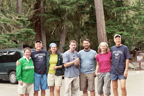
After a good night's sleep we awoke in the forest. It was peaceful. Here's my dad with the rest of the story...
Friday, Day 5 – A Walk Out of the Park
I think we slept well, at least I don’t remember waking up during the night or even hearing Fred snore. I had thought about sleeping under the stars but I was too tired to even make that decision. Fred and I crawled out of the tent to another beautiful day. Katie was already up, sitting on a log reading her book, enjoying her sneakers. Christina was sound asleep under the stars, Grace in her tent and Steve had already left to find Dale. When the kids were young I used to wake them with a serenade such as “rise and shine my little daffodils”; I tried it again and it met with the same groaning reaction – “go away Dad” usually followed by a flying object. It was about 7:00 AM and none of us were in any great hurry. It had been a great trip and I had mixed feelings about it ending. I knew that the parking lot meant no more heavy pack, decent food, a shower and a comfortable bed. But it also meant the end of this incredible adventure; one that I dreamed about but now realized that even in my wildest dream couldn’t begin to imagine what it was really like.
We all slowly went about our morning routines: coffee, stretching, emptying our tents, that walk in the woods or to the open-air facilities. Breakfast was still optional and given the choice between an MRE or the very real possibility of real food only 3 miles away; well you figure it out. Steve finally returned with Dale and all was well. I was munching on one of Fred’s Power Bars and had set it down to tie my boots when this giagundic chipmunk decided he wanted to share it. This guy was more like a squirrel-munk. When I chased him away he became rather indignant and sat under a branch scolding me. Steve saw the opportunity for fresh meat and was about to go after it with a hiking pole when the sisters intervened with “you kill it you eat it”. Now that would hardly stop the brother.
We packed up for the last time, each of us trying to locate our lost piece of gear. I was sure I lost my cell phone and a black bag for the crampons. The phone later turned up but not the bag. Katie is still missing a pair of gaiters but she did have her comfy sneakers for the last 3 miles. We never did find a good way to stuff sleeping bags other than just stuff them. My one remaining luxury was a clean tee shirt. With everything packed and loaded up, it was time for our walk out of the park.
Our packs were lighter and we were hiking down a slight grade and there may have been a bounce in our step. I recall taking time to marvel at the scenery; the tall trees, the mountain, the river on our right, the variety of wild flowers; I would miss this place and think of it often. We passed other climbers and day hikers heading up; they were bright and full of anticipation, we were grubby and full of memories. We crossed the stream a few times, climbed around the fallen trees; came to the spot where Katie uttered that memorable line about the summit, “that’s not so big”; it was an enjoyable walk but it seemed to be getting longer rather than shorter. Hikers told us only about another half mile to go. Then we heard “Hi Mom, we came looking for you guys”. It was Seamus and Matt and those had to be the sweetest words Katie had heard in a long time. He nearly knocked us over with his hugs. “Hi Mr. Fred, Hi Ofa, we came looking for you guys.” Talk about a real pick-me-up, the last half mile was a piece-a-cake. Matt thankfully took Katie’s pack and with it much of the pressure and stress off her knee. With shortened hiking poles Seamus led us out of the park.
Kathy, Arlene and Matt welcomed us with bananas, grapes, juice, milk and sandwiches and the offer of lunch down the road. A perfect ending to a perfect adventure.
Final Thoughts...
I can remember that I was in pain but I can’t experience the pain again.
I can remember that I was exhausted but I can’t experience the exhaustion again.
The beauty is that I can remember the excitement and thrill of many of the moments on the mountain and I can still experience those same choked-up feelings. There is no way to sum up this whole experience. It was difficult, it was exhausting, it was painful. It was thrilling, it was spectacular, it was the best experience a Dad could have with his kids. During our descent, Fred and I commented that this was a once-in-a-life-time experience; well maybe… but maybe not….
Monday, October 15, 2007
Mount Rainier Trek - Day 4
Our summit at 12,000 ft. was just the beginning of our longest day on the mountain. Over the next 12 hours we descended over the same path as we'd come up, but the terrain had changed. Here's my dad to tell you about it...
Thursday, Day 4 – Our Rapid Descent
We were all tired from lack of sleep and the low oxygen level.
Fred was hurting head to toe, inside and outside.
Steve’s headaches were becoming more severe.
I was angry at the incessant wind and frustrated that it had kept us awake and slowed our progress.
AMS was taking its toll on all of us.
Only Christina, at the lead position, seemed to be in relatively good shape.
We had pushed our safety factor to the limit.
Steve looked to the summit and the west to see some ominous clouds cresting the mountain and coming our way.
Fortunately, among the four of us we were able to find enough common sense to start our rapid descend.
We radioed to Grace and Katie and told them our plan; you could almost sense the relief in their voices.
The sun was up and with our backs to the wind our visibility improved. Several hundred feet below we could see our gear lashed to the mountainside at our high camp, our next goal. We reminded ourselves that most accidents happen on the way down when climbers are most vulnerable due to fatigue and a sense of accomplishment. Going down uses a whole different set of muscles and different techniques with poles and ice axes. Not any more difficult, just different, plus you have gravity in your favor. Steve reminded us that the lower we got the better we would feel; Christina kept singing the praises of O2. Fred forgot to take pictures at our summit, later he told us he was too busy trying to stay alive. Going down gives you an entirely different view. On the way up you face the mountain, looking down for each successive step, looking up to see the snow or rock that you need to climb. On the way down you get to see the beauty of the surrounding mountains and valleys and rivers and sky. You also get the full realization of what you have accomplished; where you started, the route you took, the glaciers you crossed; it’s a great feeling that helps to mask the pain you are experiencing. We started down.
Mother nature wasn’t finished with us. We had descended a short distance when we were hit by what felt like ice pellets. We dug our ice axes into the snow and held on. It was like this most of the way down to high camp. After a brief rest at high camp we loaded up our packs and continued down towards base camp. We maintained radio contact with Grace and Katie who were watching us descend. They in turn sent messages to Matt so he could keep Kathy and Arlene appraised. They were also readying everything at base camp so we could continue on down. We were making good progress. In the process of crossing a crevasse, about 4 feet wide followed by a steep slope, Steve yelled SNOW SLIDE – RUN. Christina and I were across the crevasse, Fred probably in mid-air and Steve still dug-in to protect Fred from a fall; and we heard SNOW SLIDE – RUN. Christina and I ran and slid down the mountain dragging Fred behind us and in a single leap Steve bounded over the crevasse and slid down with us. We looked back and saw a cloud of snow as the avalanche went by and fell into another crevasse. It was really cool. Sliding was fun too, so we continued to slide down perhaps another hundred yards.
The avalanche fell into a crevasse above us at this spot on the mountain... you can see two little dots of us in the center of the frame. Follow the zig-zag foot path up the snowfield, we are at the point on the path where the glacier breaks. This is near the same location where I fell into the crevasse the day before...

With Christina still in the lead, we approached our final set of crevasses above base camp, negotiated them without incident and in a few hundred yards were on solid ground at Camp Schurman. We had come down 2500 ft, the air was better, the water refreshing and yet the thoughts of food were still …, let me just say we weren’t ready for any. I do recall sitting at base camp eating a packet of peanut butter and trying to figure out what I needed to do next. I also recall thinking we were less than half way down to Glacier Basin Camp.

Fred resting up for the next descent...

While we were having fun on the slopes, Grace and Katie were becoming good friends with Abby. They also restocked the water supply and sorted all the gear and gave all our excess food and fuel to Abby, now that significantly lightened our load. Abby even took a lot of our trash; better to take it down by helicopter she said, rather than for us to carry it – thanks Abby.
We rested for perhaps an hour, loaded up, roped up, said our good-byes to Abby and Camp Schurman and headed out. The scary snow-bridge was now a pile of rubble at the base of a 50 ft deep crevasse. We took the long way around and started down Emmons Glacier, Christina in the lead. We wound our way through the crevasse field that had changed a bit in the few days since our ascent. One crevasse in particular stands out in our minds; about a four foot jump onto a four foot landing spot of ice, don’t go any farther or you fall down the next crevasse.
We were so focussed during this part of our descent that no one managed to take a photo of the terrain. It's hard to forget though, and here's a sketch of the rotting ice of the mid-Emmonds glacier...

Over time, this event will require a Herculean leap to stick a 10 point landing on a postage stamp; well maybe I exaggerate. We all made it and were starting to feel really good about our mountaineering skills. We stepped off Emmons Glacier, paid proper tribute to the “special sisters spot” and started up the loose dirt and rock ridge. At the top of the ridge we stopped for a brief rest and to enjoy the view; we were aware that as we descended we would lose this spectacular view. There are no trees at this elevation and very little if any vegetations at all. The rocks are interesting in that there is such a variety; Christina found a good one for Kathy. The air seemed thicker and I guess we were probably starting to feel a little better. Well maybe that’s a stretch.
We descended the ridge onto Inter Glacier and met another team heading up. It was Thursday and the weekend climbers were arriving. Fun time again and we took the opportunity to slide down maybe a few hundred feet before we started to encounter ice. Snow is ok, but ice can be a real pain even with crampons. A few days earlier it was all snow. There were some crevasses but they were narrow and not a problem. What was quite interesting was that we were walking on the ice that forms the White River that we could see below. At one crevasse I stopped to listen to the water flowing beneath the glacier. It was a narrow one, very deep, the thickness of the glacier, deep blue as it went down and the sound of running water. Very cool. The concerns we had as we descended were slipping on the ice and the constant hazard of rock falls. Once a rock loosens from the glacier it becomes an unguided missile bouncing erratically down the mountain; sometimes picking up friends in it travels. Can be very dangerous.
The InterGlacier from below after our descent. The gray areas in the center are ice where just two days earlier it was snow.
.jpg)
We were all hurting, our equipment needed adjusting, tighten boots, tighten crampons, remove outer layers; but icy slopes are a bad place to stop. We actually lost our way on a wide open glacier and changed directions a couple times. The sun was starting to get blocked by clouds and would soon be hidden by a ridge on our left. Just over the next crest was the last snow field on the glacier. We started to slide down but Katie got her leg caught in a rope and twisted her knee. Katie did not have a good experience on Inter Glacier; either going up or down. Fred’s feet were really hurting so he and Steve continued to slide down the last few hundred yards to the bottom while Katie, Grace, Christina and I walked down. At last solid ground once again, no more snow or ice, relatively solid path and only 2 miles to camp.
The team sort of strung out during this last hike to camp. Steve and Grace seemed to have more energy than the rest of us and soon were way ahead. Katie and Fred about 100 yards behind them and Christina and I dawdling at the back. Oh, I forget to tell you earlier that this was the area where we had seen several wild sheep on our way up. I don’t know what they were surviving on as there is no vegetation where they were headed. Keep in mind that this area is covered with snow and ice most of the year so flowers don’t have much of a chance to flourish. Off to the sides where the glaciers didn’t encroach, there was a variety of plant life and small patches of grass and some really big granite boulders that look out of place. The lower we got the more vegetation we encountered until we were surrounded by trees at the camp site.
As I mentioned, Steve was way ahead of us, got to camp then returned to meet us on the trail to carry my pack to camp then returned again to carry Fred’s. By the time Fred and I reached camp Steve & Grace had already set up our tent; which was a good thing because we might not have had the energy to even bother. Katie retrieved her very comfortable sneakers that she had cached in a tree; Christina filled the water bottles and Grace boiled them. Food was essential but Fred and I were still treating it as optional. Christina had been giving all of us some magic elixir each night that was supposed to cure what ails you, it tasted terrible and I confess to not drinking my daily prescription. Fred on the other hand did and it probably helped him as he and food were still very much strangers. I was able to force down a half portion of ravioli that night along with a generous serving of water, a snack bar and some elixir. Messages were sent to Matt and Kathy that we hoped to arrive at the parking lot at about 11:00 AM the next day and it sure would be nice if they could bring a few items like real food, milk, beer ….
This very long day was nearly over for our team. We had started at about 2:00 AM after an almost sleepless night, attempted to summit, got pretty well beat up by the wind and descended 6000 ft to Glacier Basin Camp arriving at about 5:30 PM; exhausted.
While all this was going on there was the other team that did summit. I wrote about that team in “By the Numbers” but it bears repeating here. That team consisted of 3 climbers: 2 climbers who were making their 71st ascent in 30 years (and refused to miss a year) and accompanied by Dale, an Army friend of Steve’s – Special Forces, attached to the Army Northern Warfare School stationed in Alaska, extensively trained in mountaineering. They met with us at about 3:00 AM at our high camp on their ascent. Their ascent and return to base camp took 14 hours, normally 8 hrs to 10 hrs. Our team at 12000 ft was the second highest team that day.
Dale had been in radio contact with Steve throughout the day. Unfortunately during their climb Dale had suffered snow blindness and was having difficulty making it down. He was hoping to meet with us at Glacier Basin Camp. At 6:00 PM Steve ascended once again to about 8500 ft to find Dale who by this time was "mis-oriented" on the rocky ridge separating Emmons and Inter Glaciers. They were in radio contact but could not connect. They decided Dale would camp where he was and Steve returned to Glacier Basin, arriving at about midnight. Friday at about 6:00 AM Steve headed back up the mountain, found Dale and they returned to Glacier Basin Camp. Steve’s ability and dedication to his fellow officer enabled him to push himself well beyond what any of us might expect.
That was our day; one of the most physically and mentally taxing and memorable we have had.
Here's a link to the route we took on Day 4 on mapmyrun.com. At the bottom of the map click "Topo" or "Satellite" for a better look at the route and "Show Elevation" to see more detail of the route.
Thursday, Day 4 – Our Rapid Descent
We were all tired from lack of sleep and the low oxygen level.
Fred was hurting head to toe, inside and outside.
Steve’s headaches were becoming more severe.
I was angry at the incessant wind and frustrated that it had kept us awake and slowed our progress.
AMS was taking its toll on all of us.
Only Christina, at the lead position, seemed to be in relatively good shape.
We had pushed our safety factor to the limit.
Steve looked to the summit and the west to see some ominous clouds cresting the mountain and coming our way.
Fortunately, among the four of us we were able to find enough common sense to start our rapid descend.
We radioed to Grace and Katie and told them our plan; you could almost sense the relief in their voices.
The sun was up and with our backs to the wind our visibility improved. Several hundred feet below we could see our gear lashed to the mountainside at our high camp, our next goal. We reminded ourselves that most accidents happen on the way down when climbers are most vulnerable due to fatigue and a sense of accomplishment. Going down uses a whole different set of muscles and different techniques with poles and ice axes. Not any more difficult, just different, plus you have gravity in your favor. Steve reminded us that the lower we got the better we would feel; Christina kept singing the praises of O2. Fred forgot to take pictures at our summit, later he told us he was too busy trying to stay alive. Going down gives you an entirely different view. On the way up you face the mountain, looking down for each successive step, looking up to see the snow or rock that you need to climb. On the way down you get to see the beauty of the surrounding mountains and valleys and rivers and sky. You also get the full realization of what you have accomplished; where you started, the route you took, the glaciers you crossed; it’s a great feeling that helps to mask the pain you are experiencing. We started down.
Mother nature wasn’t finished with us. We had descended a short distance when we were hit by what felt like ice pellets. We dug our ice axes into the snow and held on. It was like this most of the way down to high camp. After a brief rest at high camp we loaded up our packs and continued down towards base camp. We maintained radio contact with Grace and Katie who were watching us descend. They in turn sent messages to Matt so he could keep Kathy and Arlene appraised. They were also readying everything at base camp so we could continue on down. We were making good progress. In the process of crossing a crevasse, about 4 feet wide followed by a steep slope, Steve yelled SNOW SLIDE – RUN. Christina and I were across the crevasse, Fred probably in mid-air and Steve still dug-in to protect Fred from a fall; and we heard SNOW SLIDE – RUN. Christina and I ran and slid down the mountain dragging Fred behind us and in a single leap Steve bounded over the crevasse and slid down with us. We looked back and saw a cloud of snow as the avalanche went by and fell into another crevasse. It was really cool. Sliding was fun too, so we continued to slide down perhaps another hundred yards.
The avalanche fell into a crevasse above us at this spot on the mountain... you can see two little dots of us in the center of the frame. Follow the zig-zag foot path up the snowfield, we are at the point on the path where the glacier breaks. This is near the same location where I fell into the crevasse the day before...
With Christina still in the lead, we approached our final set of crevasses above base camp, negotiated them without incident and in a few hundred yards were on solid ground at Camp Schurman. We had come down 2500 ft, the air was better, the water refreshing and yet the thoughts of food were still …, let me just say we weren’t ready for any. I do recall sitting at base camp eating a packet of peanut butter and trying to figure out what I needed to do next. I also recall thinking we were less than half way down to Glacier Basin Camp.
Fred resting up for the next descent...
While we were having fun on the slopes, Grace and Katie were becoming good friends with Abby. They also restocked the water supply and sorted all the gear and gave all our excess food and fuel to Abby, now that significantly lightened our load. Abby even took a lot of our trash; better to take it down by helicopter she said, rather than for us to carry it – thanks Abby.
We rested for perhaps an hour, loaded up, roped up, said our good-byes to Abby and Camp Schurman and headed out. The scary snow-bridge was now a pile of rubble at the base of a 50 ft deep crevasse. We took the long way around and started down Emmons Glacier, Christina in the lead. We wound our way through the crevasse field that had changed a bit in the few days since our ascent. One crevasse in particular stands out in our minds; about a four foot jump onto a four foot landing spot of ice, don’t go any farther or you fall down the next crevasse.
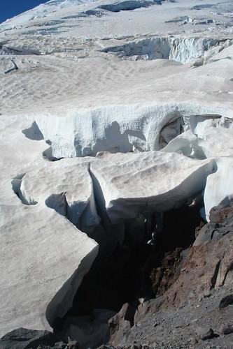
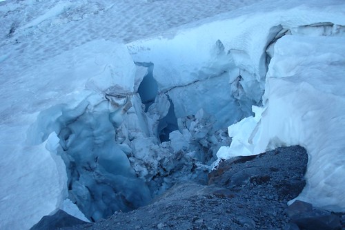
We were so focussed during this part of our descent that no one managed to take a photo of the terrain. It's hard to forget though, and here's a sketch of the rotting ice of the mid-Emmonds glacier...

Over time, this event will require a Herculean leap to stick a 10 point landing on a postage stamp; well maybe I exaggerate. We all made it and were starting to feel really good about our mountaineering skills. We stepped off Emmons Glacier, paid proper tribute to the “special sisters spot” and started up the loose dirt and rock ridge. At the top of the ridge we stopped for a brief rest and to enjoy the view; we were aware that as we descended we would lose this spectacular view. There are no trees at this elevation and very little if any vegetations at all. The rocks are interesting in that there is such a variety; Christina found a good one for Kathy. The air seemed thicker and I guess we were probably starting to feel a little better. Well maybe that’s a stretch.
We descended the ridge onto Inter Glacier and met another team heading up. It was Thursday and the weekend climbers were arriving. Fun time again and we took the opportunity to slide down maybe a few hundred feet before we started to encounter ice. Snow is ok, but ice can be a real pain even with crampons. A few days earlier it was all snow. There were some crevasses but they were narrow and not a problem. What was quite interesting was that we were walking on the ice that forms the White River that we could see below. At one crevasse I stopped to listen to the water flowing beneath the glacier. It was a narrow one, very deep, the thickness of the glacier, deep blue as it went down and the sound of running water. Very cool. The concerns we had as we descended were slipping on the ice and the constant hazard of rock falls. Once a rock loosens from the glacier it becomes an unguided missile bouncing erratically down the mountain; sometimes picking up friends in it travels. Can be very dangerous.
The InterGlacier from below after our descent. The gray areas in the center are ice where just two days earlier it was snow.
.jpg)
We were all hurting, our equipment needed adjusting, tighten boots, tighten crampons, remove outer layers; but icy slopes are a bad place to stop. We actually lost our way on a wide open glacier and changed directions a couple times. The sun was starting to get blocked by clouds and would soon be hidden by a ridge on our left. Just over the next crest was the last snow field on the glacier. We started to slide down but Katie got her leg caught in a rope and twisted her knee. Katie did not have a good experience on Inter Glacier; either going up or down. Fred’s feet were really hurting so he and Steve continued to slide down the last few hundred yards to the bottom while Katie, Grace, Christina and I walked down. At last solid ground once again, no more snow or ice, relatively solid path and only 2 miles to camp.
The team sort of strung out during this last hike to camp. Steve and Grace seemed to have more energy than the rest of us and soon were way ahead. Katie and Fred about 100 yards behind them and Christina and I dawdling at the back. Oh, I forget to tell you earlier that this was the area where we had seen several wild sheep on our way up. I don’t know what they were surviving on as there is no vegetation where they were headed. Keep in mind that this area is covered with snow and ice most of the year so flowers don’t have much of a chance to flourish. Off to the sides where the glaciers didn’t encroach, there was a variety of plant life and small patches of grass and some really big granite boulders that look out of place. The lower we got the more vegetation we encountered until we were surrounded by trees at the camp site.
As I mentioned, Steve was way ahead of us, got to camp then returned to meet us on the trail to carry my pack to camp then returned again to carry Fred’s. By the time Fred and I reached camp Steve & Grace had already set up our tent; which was a good thing because we might not have had the energy to even bother. Katie retrieved her very comfortable sneakers that she had cached in a tree; Christina filled the water bottles and Grace boiled them. Food was essential but Fred and I were still treating it as optional. Christina had been giving all of us some magic elixir each night that was supposed to cure what ails you, it tasted terrible and I confess to not drinking my daily prescription. Fred on the other hand did and it probably helped him as he and food were still very much strangers. I was able to force down a half portion of ravioli that night along with a generous serving of water, a snack bar and some elixir. Messages were sent to Matt and Kathy that we hoped to arrive at the parking lot at about 11:00 AM the next day and it sure would be nice if they could bring a few items like real food, milk, beer ….
This very long day was nearly over for our team. We had started at about 2:00 AM after an almost sleepless night, attempted to summit, got pretty well beat up by the wind and descended 6000 ft to Glacier Basin Camp arriving at about 5:30 PM; exhausted.
While all this was going on there was the other team that did summit. I wrote about that team in “By the Numbers” but it bears repeating here. That team consisted of 3 climbers: 2 climbers who were making their 71st ascent in 30 years (and refused to miss a year) and accompanied by Dale, an Army friend of Steve’s – Special Forces, attached to the Army Northern Warfare School stationed in Alaska, extensively trained in mountaineering. They met with us at about 3:00 AM at our high camp on their ascent. Their ascent and return to base camp took 14 hours, normally 8 hrs to 10 hrs. Our team at 12000 ft was the second highest team that day.
Dale had been in radio contact with Steve throughout the day. Unfortunately during their climb Dale had suffered snow blindness and was having difficulty making it down. He was hoping to meet with us at Glacier Basin Camp. At 6:00 PM Steve ascended once again to about 8500 ft to find Dale who by this time was "mis-oriented" on the rocky ridge separating Emmons and Inter Glaciers. They were in radio contact but could not connect. They decided Dale would camp where he was and Steve returned to Glacier Basin, arriving at about midnight. Friday at about 6:00 AM Steve headed back up the mountain, found Dale and they returned to Glacier Basin Camp. Steve’s ability and dedication to his fellow officer enabled him to push himself well beyond what any of us might expect.
That was our day; one of the most physically and mentally taxing and memorable we have had.
Here's a link to the route we took on Day 4 on mapmyrun.com. At the bottom of the map click "Topo" or "Satellite" for a better look at the route and "Show Elevation" to see more detail of the route.
Sunday, October 14, 2007
Mount Rainier Trek - interlude
In my family, it's a time honored tradition to but in while someone else is talking. So here I am with a few editorial comments on the trek from Camp Schurman to 12,000 ft.
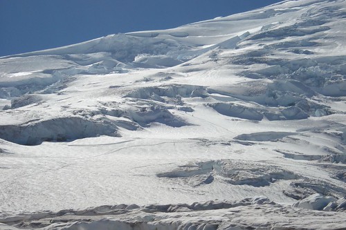
We set out from Camp Schurman following the tracks of the teams that had left earlier in the morning, and we took it slow. We had to pick our way through some parts of the terrain. There were snow bridges to cross over crevasses directly above Camp Schurman and higher up there were large crevasses carved into the side of the mountain created by icefalls on the glacier.
We met Abby and Sam at a critical route-finding point where I'd watched an earlier team lose their way among an icefall. After chatting with them about conditions above we followed their tracks and continued up the mountain. Stepping on one of their footprints I punched through a snowbridge and fell to my waist into a narrow crevasse. My pack stopped the fall. I rolled out fairly easily - none the worse for the experience and enjoying a mild shot adrenaline. To be honest though, that's as much falling into crevasses as I ever hope to do.
The way became easier past the icefall and we made camp as described by my dad. The view from our snowledge was mind-blowing. The sun set behind the mountain and backlit the Olympic mountains with pink and purple hues. The lights began to blink on in Puget Sound from Tacoma up past Everett, and to the east I could see out over the Cascade Range to the see the lights in Yakima.
I kept hearing a plane flying around nearby, and I looked all around but didn't see it. The wind was picking up and I was pretty focussed on melting snow into water for the next stage of our climb. After dark, the wind became ferocious. As I lay in my tent, the carbs I'd eaten on arriving at camp all hit my system at once. Starting in my legs, all my muscles started to dance the jitterbug - it's like they were all partying it up on the sugar without inviting me. It was a little freaky to be uncontrollably shaking but I realized as long as my core was still warm I'd probably be OK. The rave subsided after about a half an hour, though as with most rockin' parties, there were lingering revellers for hours.
When Dale arrived, the wind was still howling and none of us had slept. My brother and I had agreed earlier that we wouldn't ask anyone, "are you sure you want to keep going?" We wanted to allow everyone to make their own decisions and not feel pressure one way or another to continue or to stop. As I saw my dad and Fred begin to pack up for a summit attempt, I looked at my brother. He looked at me. We at the old guys. They were going to go for it. I was impressed. I thought: Either those guys have some serious cohones, or they're hypoxic. Then I figured it was probably both and I started to focus the climb ahead.
On reflection, I'm glad we started up while it was dark. The first couple hundred feet were fine, but then we encountered some serious crevasses - a huge gash in the mountain with enormous blocks of ice fallen into them - crossed by a narrow ice bridge. I focussed on the tracks from Dale's team and keeping my eyes within the narrow spot of light from my headlamp I followed their trail through the ice fall. A few hours later in the daylight as we were passing back through it, I almost couldn't pry my eyes from that hole in the mountain. Had it been light on the way up, I might not have had the focus to cross.
I'm glad we stopped at 12,000 ft. Up until that elevation, I felt solid. But as the sun came up I was just starting to feel it - that point where it's time to dip into the deep reserves - where raw gut and determination were going to have to take over. I could do it, but I was at the lead of a rope with three others attached. And we still had to get back down the mountain. There was a lenticular forming over the summit, and it was a deep gray in color. That's a sign of high wind and weather. It was a good decision to turn around then. The energy we would have spent continuing upward was better held in reserve for the trip back down the mountain. We still had a very long day ahead of us.
Thursday, October 11, 2007
Mount Rainier Trek - Day 3
Looking up towards the summit from Camp Schurman

Our third day on the mountain started with a modest goal, to position the team at a higher elevation and get a couple hours sleep before our summit attempt. As we climbed higher the terrain became more exposed and the weather began to change. By the end of the day as we carved our camp into the side of the mountain the wind began to pick up...
I'll let my dad tell you about it.
That Night on the Mountain
Wednesday, Aug 29, Day 3: The day started beautifully, the high that had been in place for the past few days was still there. The sky was blue, the air fresh and the view from 9525 ft was spectacular. Steve couldn’t believe that the old guys had actually slept 11 hours; the old guys couldn’t believe it was only 11 hours. The original plan had been to spend the day doing more rope training; belaying, etc, and resting for our assault on the summit Thursday. But plans do change…
After the experiences of the day before, Grace and Katie decided that for this trip they had reached their summit. I can’t wait to read what they have to say about their climb to 9525 ft. Steve and Christina thought it would be a good idea to get a head start on our summit attempt by climbing up another couple thousand feet and setting up a high camp above The Corridor. The old guys agreed so we set the plan in motion. We were to take only what we needed for 2 days, leaving any excess gear at base camp with Grace and Katie. Katie and Grace made sure we each had a full complement of water, we checked all radios, applied yet another coating of sun block on all exposed skin including up our noses, geared up, roped up, and with ice axes and poles in hand set off. Our packs were considerably lighter, which buoyed our enthusiasm.

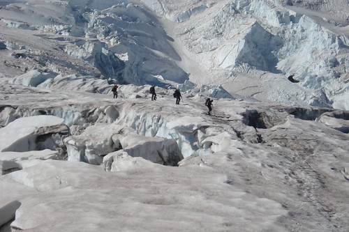
Much earlier that day, 5:00 AM, 2 other climbers set off for the summit, as did the Ranger, Sam, and his girl friend, Abby, at about 7:00 AM. Stepping off of Camp Schurman onto the Emmons Glacier was the easy part. Christina was in lead and was following the tracks from the earlier climbers. Within a hundred yards we encountered our first set of crevasses and negotiated them with little difficulty. It’s amazing how much we learned the day before and how our confidence had increased under the leadership of Steve and Christina.
This photo was taken an hour after we left Camp Schurman.

After climbing for a while we met up with Sam and Abby who were returning from 12000 ft; they ended their climb at that elevation because of the late start and the wind was starting to kick up. They showed us a better route and told us of a primo camping spot up a ways. We set off as they recommended, went about 50 feet and Christina suddenly broke through a snow bridge dropping up to her waist into a crevasse. A scary moment for all (see Grace’s account of Scary Moments). We can joke about it now but at the time it was quite a shock and made us all the more cautious.
The wind picked up and we continued upward with visions of a flat area where we could set up camp. Then at about 11240 ft elevation Steve said this is the spot; the old guys looked around trying to find the flat primo campsite we had been promised; not to be found. Because of the grade we remained roped up and started digging ledges to create our own flat primo campsite. We worked for about 20 minutes, I’d say that Steve and Fred did the lions share of the digging. The initial ledge was about 20 ft long and 4 ft wide dug into a slope of maybe 30 degrees. Because the wind continued to gust with increasing force, we built walls on the uphill side to deflect the wind and protect the tents.
Acute Mountain Sickness (AMS) was beginning to take its toll. Steve and Fred were experiencing severe headaches, Fred and I did not want to even think about food, Fred got sick again, and we were all exhausted. Steve placed some anchors into the snow so we could anchor our gear and ourselves to the side of the mountain for the night. Christina continued to melt snow to refill our water supply. We finally all crawled into our tents. All that is except Steve who prefers to sleep in a bivi-bag rather than a tent.
While this was going on we got a radio message from Grace and Katie that Dale had arrived at our base camp with 2 other climbers. Grace and Katie had been purifying water most of the day and refilled the new team. Steve asked Dale if he wanted to join us at high camp but he very colorfully declined. A word about Dale: he is a friend of Steve’s from West Point, presently in Special Forces having just returned from Iraq. Prior to Iraq, he had spent a few years stationed in Alaska with the Army Northern Warfare and has extensive mountaineering experience. The 2 climbers he was accompanying were on their 71st climb up Rainier in the past 30 consecutive years. They had done the climb from White River Camp (4320 ft) to Camp Schurman (9525 ft) in about half the time it took us.
We heard a plane flying overhead and got a radio message from Grace and Katie that it was Mark. We were all too tired to crawl out of our tents to look (sorry Mark). He took a lot of pictures which you can see through this link. Mark later told us about his unique experience; on one side of the mountain he caught an updraft that increased his elevation at about 1000 ft per minute and on the other side pushed him down at about 700 ft per minute. He was also able to fly over the mountain; you do the math on that one, quite a feat for a small plane.
Here's one of the photos Mark took of Camp Schurman and the Emmonds Glacier. Camp Schurman is located at the top of those two rock ridges that join in a V pointing up towards the summit.

The wind increased, tents were blowing as we hunkered down for the night at about 6:00 PM. Our plan was to get a good night sleep, arise at 2:00 AM to be ready to hook up with Dale at about 3:00 AM and head for the summit. Good plan. Well, there was no good night sleep. The wind howled all night collapsing our tents so they looked more like nylon wraps rather than tents. Amazingly, when the wind let up the tents would spring back into their normal shape. Later Steve told me that he had already developed his rescue plan should Fred's and my tent rip apart.
We didn’t think we got any sleep but apparently our snoring belied that. As I lie there all night waiting for the tent to rip apart, I thought that this was just a nighttime blow that would soon end; wrong again. At one point Christina called to Steve that she had the shakes; she was warm enough but couldn’t stop shaking. Steve hollered back to hang in there because there was nothing we could do until the AM. In a short time she calmed down and realized she probably had too much sugar. Throughout his Army career Steve has spent a lot of bad nights in the wilderness but he counts this as among of the worst.
At about 2:00 AM we got a call from Grace and Katie that Dale and the other 2 climbers were heading up; we thought they were crazy. What we didn’t realize was that the 2 climbers wouldn’t be denied the summit on this or any day. They arrived, we chatted a bit and they continued up. It took us another hour to get ready: pack all our gear, anchor it to the mountain side, rope up, refill our water, try to eat and get underway. Later we learned that Grace, Katie and Abby were watching our headlamps and thought we were crazy when they saw us heading up rather than down.
The next 2 hours were perhaps the most taxing we have ever experienced. We frequently had to dig our ice axes into the snow to keep from being blown off the mountain. After two hours and only an 800 ft elevation gain, an absolutely glorious sunrise, more AMS compounded by a lack of sleep, and an unceasing wind we decided that for this trip and on this day we had reached our summit at 12000 ft.
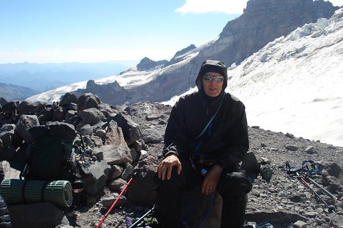
Here are Steve (below) and Fred (above) taking in the sunrise from 12,000 ft. with the Emmonds Glacier flowing down the mountain below.

Fred at 12,000 ft. and Camp Schurman below

and Dyd at 12,000 ft. with the summit Mt. Baker on the horizon 130 miles to the north and 1,300 ft below us.

Steve looked to the northwest and saw some ominous clouds cresting the mountain and heading down towards us. As we started our decent, the wind threw ice pellets at us. We know we had made the right decision. We learned later that the wind gusts at Camp Schurman (9525 ft) had been measured at 70 mph and was projected as being stronger at higher elevations. The saying goes that the lower you get the better you feel; we were all too tired to notice if we felt better.
Here's a link to the route we took on Day 3 on mapmyrun.com. At the bottom of the map click "Topo" or "Satellite" for a better look at the route and "Show Elevation" to see more detail of the route.

Our third day on the mountain started with a modest goal, to position the team at a higher elevation and get a couple hours sleep before our summit attempt. As we climbed higher the terrain became more exposed and the weather began to change. By the end of the day as we carved our camp into the side of the mountain the wind began to pick up...
I'll let my dad tell you about it.
That Night on the Mountain
Wednesday, Aug 29, Day 3: The day started beautifully, the high that had been in place for the past few days was still there. The sky was blue, the air fresh and the view from 9525 ft was spectacular. Steve couldn’t believe that the old guys had actually slept 11 hours; the old guys couldn’t believe it was only 11 hours. The original plan had been to spend the day doing more rope training; belaying, etc, and resting for our assault on the summit Thursday. But plans do change…
After the experiences of the day before, Grace and Katie decided that for this trip they had reached their summit. I can’t wait to read what they have to say about their climb to 9525 ft. Steve and Christina thought it would be a good idea to get a head start on our summit attempt by climbing up another couple thousand feet and setting up a high camp above The Corridor. The old guys agreed so we set the plan in motion. We were to take only what we needed for 2 days, leaving any excess gear at base camp with Grace and Katie. Katie and Grace made sure we each had a full complement of water, we checked all radios, applied yet another coating of sun block on all exposed skin including up our noses, geared up, roped up, and with ice axes and poles in hand set off. Our packs were considerably lighter, which buoyed our enthusiasm.
Much earlier that day, 5:00 AM, 2 other climbers set off for the summit, as did the Ranger, Sam, and his girl friend, Abby, at about 7:00 AM. Stepping off of Camp Schurman onto the Emmons Glacier was the easy part. Christina was in lead and was following the tracks from the earlier climbers. Within a hundred yards we encountered our first set of crevasses and negotiated them with little difficulty. It’s amazing how much we learned the day before and how our confidence had increased under the leadership of Steve and Christina.
This photo was taken an hour after we left Camp Schurman.
After climbing for a while we met up with Sam and Abby who were returning from 12000 ft; they ended their climb at that elevation because of the late start and the wind was starting to kick up. They showed us a better route and told us of a primo camping spot up a ways. We set off as they recommended, went about 50 feet and Christina suddenly broke through a snow bridge dropping up to her waist into a crevasse. A scary moment for all (see Grace’s account of Scary Moments). We can joke about it now but at the time it was quite a shock and made us all the more cautious.
The wind picked up and we continued upward with visions of a flat area where we could set up camp. Then at about 11240 ft elevation Steve said this is the spot; the old guys looked around trying to find the flat primo campsite we had been promised; not to be found. Because of the grade we remained roped up and started digging ledges to create our own flat primo campsite. We worked for about 20 minutes, I’d say that Steve and Fred did the lions share of the digging. The initial ledge was about 20 ft long and 4 ft wide dug into a slope of maybe 30 degrees. Because the wind continued to gust with increasing force, we built walls on the uphill side to deflect the wind and protect the tents.
Acute Mountain Sickness (AMS) was beginning to take its toll. Steve and Fred were experiencing severe headaches, Fred and I did not want to even think about food, Fred got sick again, and we were all exhausted. Steve placed some anchors into the snow so we could anchor our gear and ourselves to the side of the mountain for the night. Christina continued to melt snow to refill our water supply. We finally all crawled into our tents. All that is except Steve who prefers to sleep in a bivi-bag rather than a tent.
While this was going on we got a radio message from Grace and Katie that Dale had arrived at our base camp with 2 other climbers. Grace and Katie had been purifying water most of the day and refilled the new team. Steve asked Dale if he wanted to join us at high camp but he very colorfully declined. A word about Dale: he is a friend of Steve’s from West Point, presently in Special Forces having just returned from Iraq. Prior to Iraq, he had spent a few years stationed in Alaska with the Army Northern Warfare and has extensive mountaineering experience. The 2 climbers he was accompanying were on their 71st climb up Rainier in the past 30 consecutive years. They had done the climb from White River Camp (4320 ft) to Camp Schurman (9525 ft) in about half the time it took us.
We heard a plane flying overhead and got a radio message from Grace and Katie that it was Mark. We were all too tired to crawl out of our tents to look (sorry Mark). He took a lot of pictures which you can see through this link. Mark later told us about his unique experience; on one side of the mountain he caught an updraft that increased his elevation at about 1000 ft per minute and on the other side pushed him down at about 700 ft per minute. He was also able to fly over the mountain; you do the math on that one, quite a feat for a small plane.
Here's one of the photos Mark took of Camp Schurman and the Emmonds Glacier. Camp Schurman is located at the top of those two rock ridges that join in a V pointing up towards the summit.
The wind increased, tents were blowing as we hunkered down for the night at about 6:00 PM. Our plan was to get a good night sleep, arise at 2:00 AM to be ready to hook up with Dale at about 3:00 AM and head for the summit. Good plan. Well, there was no good night sleep. The wind howled all night collapsing our tents so they looked more like nylon wraps rather than tents. Amazingly, when the wind let up the tents would spring back into their normal shape. Later Steve told me that he had already developed his rescue plan should Fred's and my tent rip apart.
We didn’t think we got any sleep but apparently our snoring belied that. As I lie there all night waiting for the tent to rip apart, I thought that this was just a nighttime blow that would soon end; wrong again. At one point Christina called to Steve that she had the shakes; she was warm enough but couldn’t stop shaking. Steve hollered back to hang in there because there was nothing we could do until the AM. In a short time she calmed down and realized she probably had too much sugar. Throughout his Army career Steve has spent a lot of bad nights in the wilderness but he counts this as among of the worst.
At about 2:00 AM we got a call from Grace and Katie that Dale and the other 2 climbers were heading up; we thought they were crazy. What we didn’t realize was that the 2 climbers wouldn’t be denied the summit on this or any day. They arrived, we chatted a bit and they continued up. It took us another hour to get ready: pack all our gear, anchor it to the mountain side, rope up, refill our water, try to eat and get underway. Later we learned that Grace, Katie and Abby were watching our headlamps and thought we were crazy when they saw us heading up rather than down.
The next 2 hours were perhaps the most taxing we have ever experienced. We frequently had to dig our ice axes into the snow to keep from being blown off the mountain. After two hours and only an 800 ft elevation gain, an absolutely glorious sunrise, more AMS compounded by a lack of sleep, and an unceasing wind we decided that for this trip and on this day we had reached our summit at 12000 ft.
Here are Steve (below) and Fred (above) taking in the sunrise from 12,000 ft. with the Emmonds Glacier flowing down the mountain below.

Fred at 12,000 ft. and Camp Schurman below

and Dyd at 12,000 ft. with the summit Mt. Baker on the horizon 130 miles to the north and 1,300 ft below us.

Steve looked to the northwest and saw some ominous clouds cresting the mountain and heading down towards us. As we started our decent, the wind threw ice pellets at us. We know we had made the right decision. We learned later that the wind gusts at Camp Schurman (9525 ft) had been measured at 70 mph and was projected as being stronger at higher elevations. The saying goes that the lower you get the better you feel; we were all too tired to notice if we felt better.
Here's a link to the route we took on Day 3 on mapmyrun.com. At the bottom of the map click "Topo" or "Satellite" for a better look at the route and "Show Elevation" to see more detail of the route.
Subscribe to:
Comments (Atom)
